Interactive map to view dispersion curves Central and Eastern US 25 km x 25 km grid (Last update November 30, 2017)
This covers both the CUS and EUS regions and does not suffer from the edge effects at 80W on the east and 90W on the west, respectively for these models.
Changes:
- June 15, 2016: QC'd all dispersion selections made for the Oklahoma study. This involved about 20+ hours of re-picking . Caught significant errors. Added dispersion readings to Texas data set. The downloadable fiels for the 25 km x 25 km tomography have been updated.
- May 9, 2017: Added an extensive set of results from the XI array in Minnesota to focus on the short period dispersion in the Mid-Continent Rift.
- November 30, 2017: Performed a major upgrade to the software to address the difference between geodetic (geographic) latitude and geocentric latitude. Geodetic latitude is measured with result to the local vertical of the geoid while geocentric latitude is measired with respect to the center of the Earth. The following was done:
- Observations are made in geodetic units with distances computed for the ellipsoid.
- Observed endpoint latitude/longitude pairs are converted to geocentric coordinates and the group velocity is adjusted to preserve the travel time between the two points
- Tomography is run using a spherical model and using geocentric coordinates. The output is a table of geocentric latitude/longitude and group velocity.
- The program doquad accepts a user geodetic latitude/longitude, converts to geocentic and then interpolates within the quadrilateral surrounding the geodetic coordinate to give the velocity value.
- The program doquad is also used to interpolate the values of the ANT15 tomography ( http://www.ldeo.columbia.edu/~ekstrom/Projects/ANT/USANT15/
Ekström, G., Short-period surface-wave phase velocities across the conterminous United States, Phys. Earth Planet Int. (2017), http://dx.doi.org/10.1016/j.pepi.2017.07.010) which were converted to the a similar columnar format.
- The GDM52 distribution ( http://www.ldeo.columbia.edu/~ekstrom/Projects/SWP/GDM52.html.
Ekström, G., A global model of Love and Rayleigh surface wave dispersion and anisotropy, 25-250 s, Geophy. J. Int., doi:10.1111/j.1365-246X.2011.05225.x group velocity tomography) has a FORTRAN program that accepts geodetic coordinates and then converts to access the results in geocentric coordinates.
GIF Animations Updated 2017/11/30
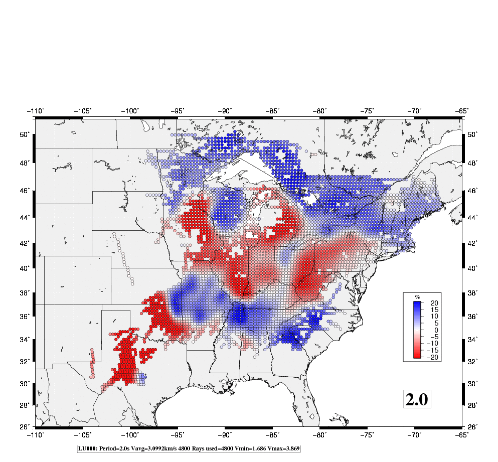
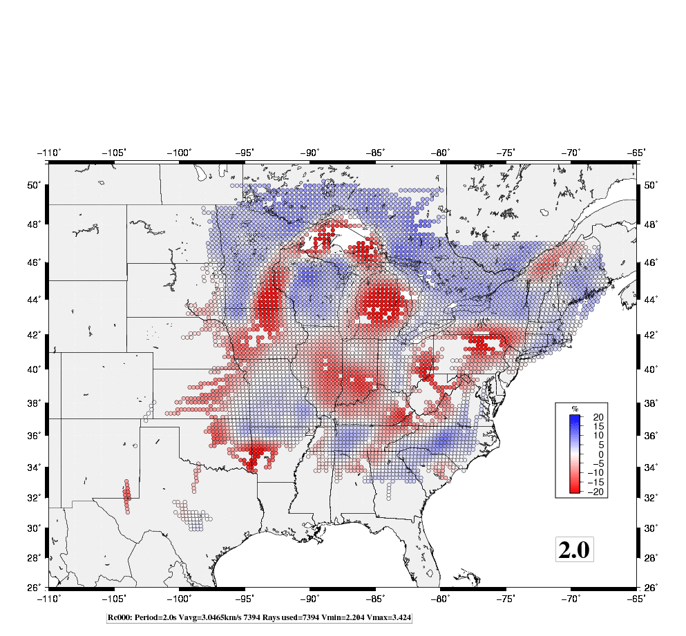
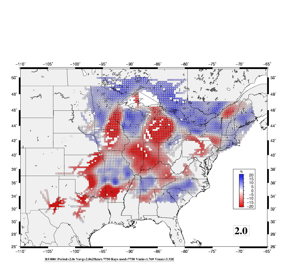
To appreciate the regional variation in dispersion, the images at discrete periods are connected in a GIF animation. In the following figures, the color scale corresponds to a ± 20%. However the original data are clipped at ± 10% in order to permit the eye to focus on small changes. The animations also serve to illustrate the completeness of the tomographic coverage. The tomographic inversion code preserved the sum of ray paths through each inversion cell. If the sum is less than 10 km, the cell dispersion in the cell is not plotted since there is no data to constrain the dispersion in that cell other than the smoothness criteria.
In the plots, the color red indicates a value slower than average, and blue faster than average. The percentages are indicated in the scaling bar.
The group velocity results are the result of earthquake and ambient noise data sets. At the longer periods, where noise data are sparse, one may see the individual ray paths between an earthquake and a station. The inversion uses only sources and receivers within the mapped area.
More experimentation is required to improve the visual presentation so that detailed information is properly conveyed.