Location
Location ANSS
The ANSS event ID is us7000ti15 and the event page is at
https://earthquake.usgs.gov/earthquakes/eventpage/us7000ti15/executive.
2026/09/17 12:31:37 49.665 -116.832 10.0 4.2 BC, Canada
Focal Mechanism
 USGS/SLU Moment Tensor Solution
 ENS  2026/09/17 12:31:37.0  49.67 -116.83  10.0 4.2 BC, Canada

 Stations used:
   CC.CRYS CC.GRWR CC.PALI CC.SUNT RV.BELVA RV.BLSTA RV.HACKA
   RV.HSPGA RV.HUGHA RV.LGPLA RV.PKSKA RV.ROCKA RV.YELLA
   TD.TD022 US.MSO US.NEW UW.AGNW UW.BDGR UW.BHAM UW.BHCR
   UW.BHW UW.BRAN UW.CBS UW.CCRK UW.COUGS UW.CVILL UW.DART
   UW.DAVN UW.DDRF UW.DONK UW.DREAM UW.DY2 UW.ETW UW.GBB
   UW.GOBBL UW.GPW UW.GUEM UW.H2O UW.HILL UW.HOPR UW.HTW
   UW.LBRT UW.LCV UW.LIGO UW.LMONT UW.LOKMT UW.LTY UW.LUMI
   UW.MANO UW.MBW2 UW.MDW UW.METAL UW.MOX UW.MULN UW.NAC2
   UW.NEL UW.OD2 UW.OLGA UW.OMAK UW.OT3 UW.PASS UW.RATT
   UW.RPW2 UW.SAW UW.SAXON UW.SHUK UW.SLF UW.SNI2 UW.SP2
   UW.TBLMT UW.TNSKT UW.TOLT UW.TUCA UW.TWISP UW.WAT2 UW.WOLL
   WW.BILL WW.KNWR

 Filtering commands used:
   cut o DIST/3.3 -40 o DIST/3.3 +50
   rtr
   taper w 0.1
   hp c 0.03 n 3
   lp c 0.08 n 3

 Best Fitting Double Couple
  Mo = 4.17e+21 dyne-cm
  Mw = 3.68
  Z  = 13 km
  Plane   Strike  Dip  Rake
   NP1       15    80   -70
   NP2      131    22   -153
  Principal Axes:
   Axis    Value   Plunge  Azimuth
    T   4.17e+21     32      88
    N   0.00e+00     20     191
    P  -4.17e+21     51     308

 Moment Tensor: (dyne-cm)
    Component   Value
       Mxx    -6.12e+20
       Mxy     8.81e+20
       Mxz    -1.19e+21
       Myy     1.95e+21
       Myz     3.49e+21
       Mzz    -1.34e+21


                     ------------##
                 ----------------######
              -------------------#########
             --------------------##########
           ----------------------############
          #----------------------#############
         #---------   ----------###############
        ##--------- P ----------################
        ##---------   ----------################
       ###---------------------##########   #####
       ###---------------------########## T #####
       ###--------------------###########   #####
       ####-------------------###################
        ####-----------------###################
        ####-----------------###################
         #####--------------###################
          #####------------###################
           ######----------##################
             ######-------#################
              #########--###############--
                 #######-----#####-----
                     ##------------


 Global CMT Convention Moment Tensor:
      R          T          P
 -1.34e+21  -1.19e+21  -3.49e+21
 -1.19e+21  -6.12e+20  -8.81e+20
 -3.49e+21  -8.81e+20   1.95e+21


Details of the solution is found at

http://www.eas.slu.edu/eqc/eqc_mt/MECH.NA/20260917123137/index.html
|
Preferred Solution
The preferred solution from an analysis of the surface-wave spectral amplitude radiation pattern, waveform inversion or first motion observations is
      STK = 15
      DIP = 80
     RAKE = -70
       MW = 3.68
       HS = 13.0
The NDK file is 20260917123137.ndk
The waveform inversion is preferred.
Magnitudes
Given the availability of digital waveforms for determination of the moment tensor, this section documents the added processing leading to mLg, if appropriate to the region, and ML by application of the respective IASPEI formulae. As a research study, the linear distance term of the IASPEI formula
for ML is adjusted to remove a linear distance trend in residuals to give a regionally defined ML. The defined ML uses horizontal component recordings, but the same procedure is applied to the vertical components since there may be some interest in vertical component ground motions. Residual plots versus distance may indicate interesting features of ground motion scaling in some distance ranges. A residual plot of the regionalized magnitude is given as a function of distance and azimuth, since data sets may transcend different wave propagation provinces.
ML Magnitude
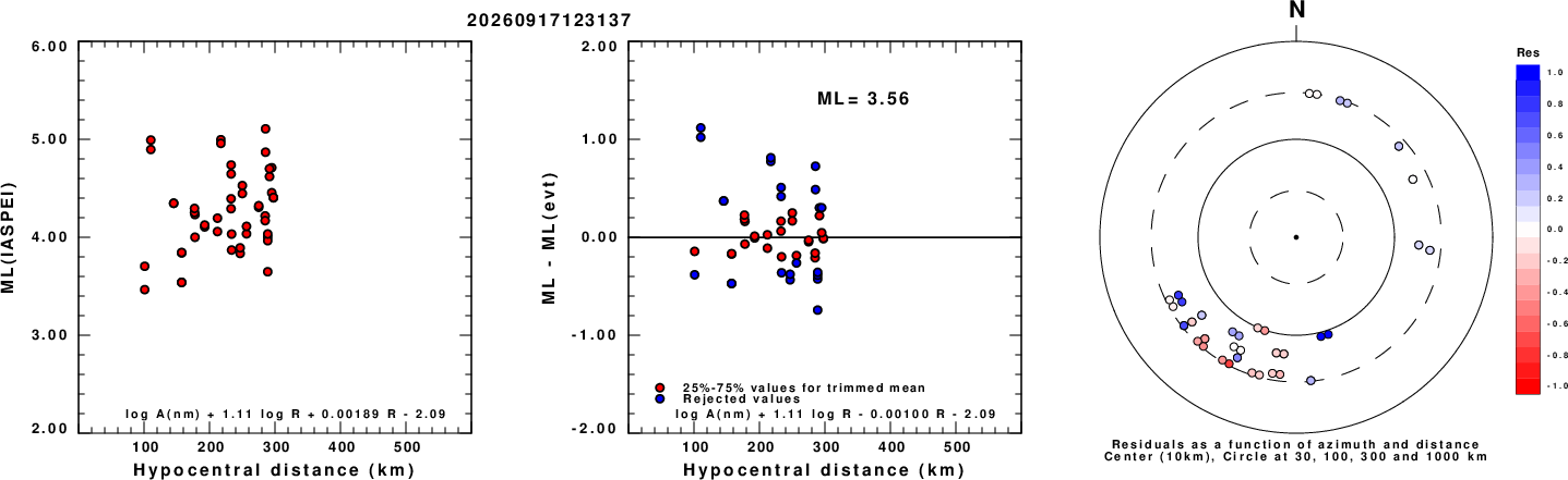
Left: ML computed using the IASPEI formula for Horizontal components. Center: ML residuals computed using a modified IASPEI formula that accounts for path specific attenuation; the values used for the trimmed mean are indicated. The ML relation used for each figure is given at the bottom of each plot.
Right: Residuals from new relation as a function of distance and azimuth.
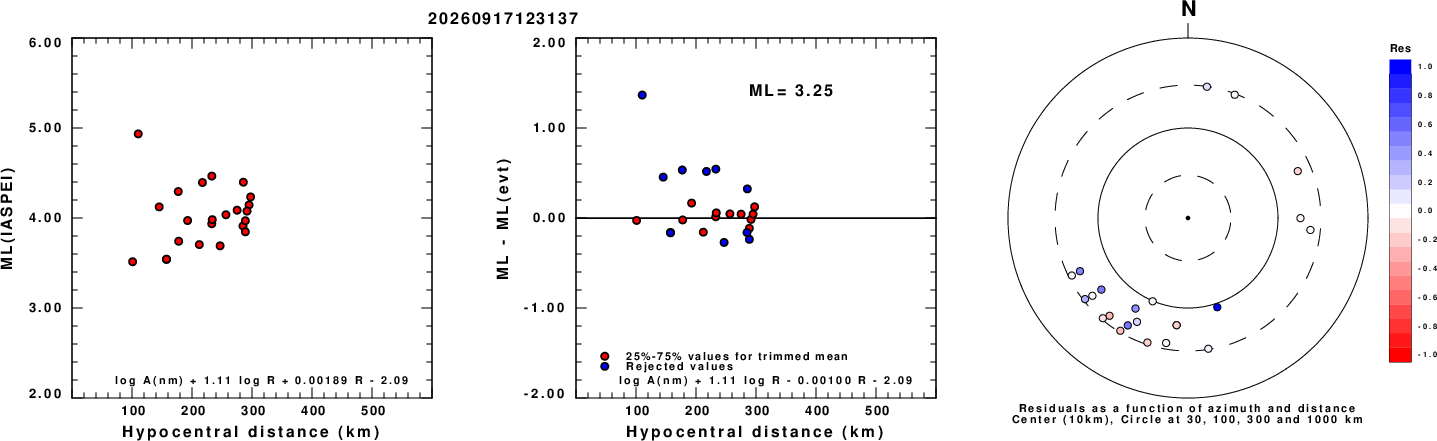
Left: ML computed using the IASPEI formula for Vertical components (research). Center: ML residuals computed using a modified IASPEI formula that accounts for path specific attenuation; the values used for the trimmed mean are indicated. The ML relation used for each figure is given at the bottom of each plot.
Right: Residuals from new relation as a function of distance and azimuth.
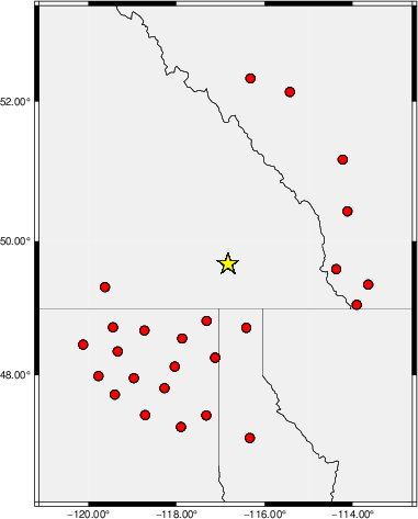
Map showing station locations used for computing the ML's. No distinction is made whether the vertical (Z) or horizontal (H) components were used.
ML Magnitude Discussion
When first processed the ML(H) of 4.04 (see the following figures) was too large for the Mw of 3.68. This is because of the many observations at large distance to the west and southwest. The interpretation is that greater attenuation there causes the distance trend to flex downward beyond 300 km, thus biasing the method used to regionalize ML. The large distance observations then control the ML estimates. The ML determined above was obtained by only using observations at distances less than 300 km.
This is a warning about determining ML in regions where there is lateral variations in the transmission properties.
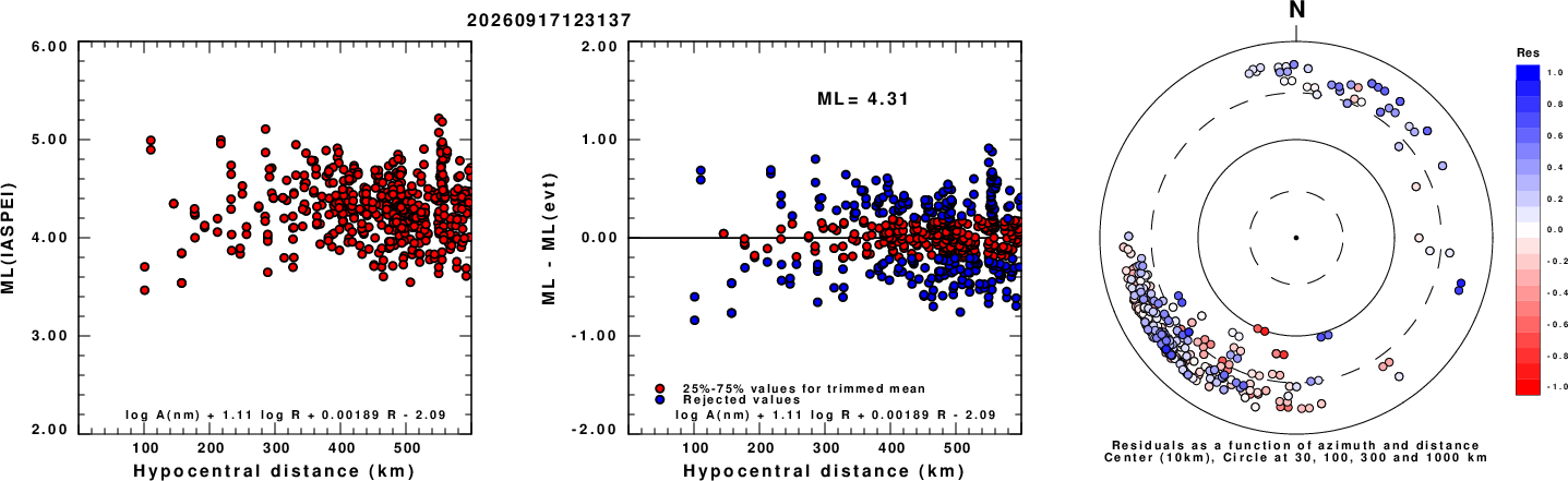
Left: ML computed using the IASPEI formula for Horizontal components. Center: ML residuals computed using a modified IASPEI formula that accounts for path specific attenuation; the values used for the trimmed mean are indicated. The ML relation used for each figure is given at the bottom of each plot.
Right: Residuals from new relation as a function of distance and azimuth.
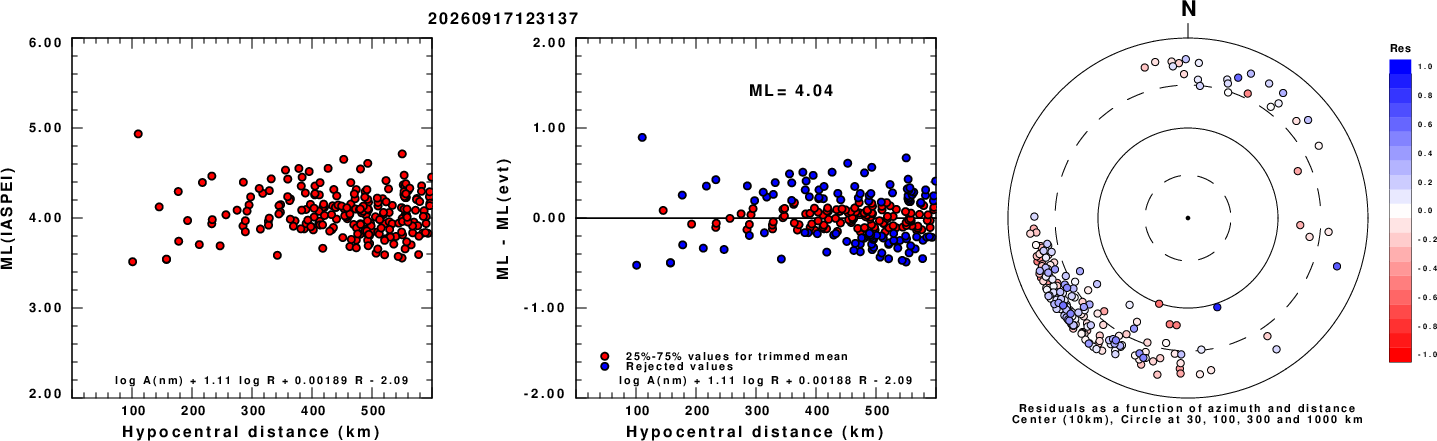
Left: ML computed using the IASPEI formula for Vertical components (research). Center: ML residuals computed using a modified IASPEI formula that accounts for path specific attenuation; the values used for the trimmed mean are indicated. The ML relation used for each figure is given at the bottom of each plot.
Right: Residuals from new relation as a function of distance and azimuth.
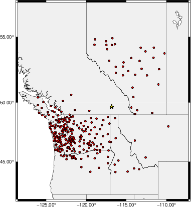
Map showing station locations used for computing the ML's. No distinction is made whether the vertical (Z) or horizontal (H) components were used.
Context
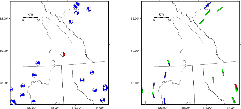
The left panel of the next figure presents the focal mechanism for this earthquake (red) in the context of other nearby events (blue) in the SLU Moment Tensor Catalog. The right panel shows the inferred direction of maximum compressive stress and the type of faulting (green is strike-slip, red is normal, blue is thrust; oblique is shown by a combination of colors). Thus context plot is useful for assessing the appropriateness of the moment tensor of this event.
Waveform Inversion using wvfgrd96
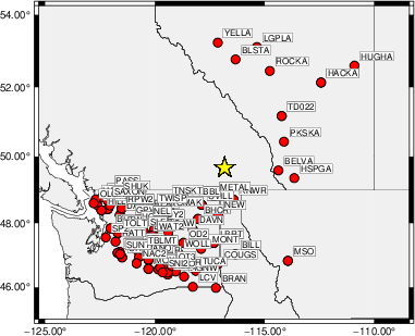
The focal mechanism was determined using broadband seismic waveforms. The location of the event (star) and the
stations used for (red) the waveform inversion are shown in the next figure.
|
|
Location of broadband stations used for waveform inversion
|
The program wvfgrd96 was used with good traces observed at short distance to determine the focal mechanism, depth and seismic moment. This technique requires a high quality signal and well determined velocity model for the Green's functions. To the extent that these are the quality data, this type of mechanism should be preferred over the radiation pattern technique which requires the separate step of defining the pressure and tension quadrants and the correct strike.
The observed and predicted traces are filtered using the following gsac commands:
cut o DIST/3.3 -40 o DIST/3.3 +50
rtr
taper w 0.1
hp c 0.03 n 3
lp c 0.08 n 3
The results of this grid search are as follow:
           DEPTH  STK   DIP  RAKE   MW    FIT
WVFGRD96    1.0    10    40   -70   3.53 0.6060
WVFGRD96    2.0   175    60   -90   3.62 0.5845
WVFGRD96    3.0    15    80   -75   3.68 0.5793
WVFGRD96    4.0    15    80   -75   3.67 0.6090
WVFGRD96    5.0    15    85   -70   3.65 0.6375
WVFGRD96    6.0    15    80   -70   3.65 0.6612
WVFGRD96    7.0    15    80   -70   3.64 0.6815
WVFGRD96    8.0    15    80   -70   3.64 0.6972
WVFGRD96    9.0    15    80   -70   3.64 0.7085
WVFGRD96   10.0    15    80   -70   3.67 0.7182
WVFGRD96   11.0    15    80   -70   3.67 0.7233
WVFGRD96   12.0    15    80   -70   3.68 0.7257
WVFGRD96   13.0    15    80   -70   3.68 0.7258
WVFGRD96   14.0    15    80   -70   3.69 0.7236
WVFGRD96   15.0    15    85   -65   3.69 0.7198
WVFGRD96   16.0    15    85   -65   3.70 0.7146
WVFGRD96   17.0    15    85   -65   3.70 0.7077
WVFGRD96   18.0    15    85   -65   3.71 0.6993
WVFGRD96   19.0    15    85   -65   3.71 0.6899
WVFGRD96   20.0    15    85   -70   3.75 0.6816
WVFGRD96   21.0    15    85   -70   3.75 0.6687
WVFGRD96   22.0    15    85   -70   3.76 0.6550
WVFGRD96   23.0    15    85   -70   3.77 0.6406
WVFGRD96   24.0    15    85   -70   3.77 0.6257
WVFGRD96   25.0    15    85   -70   3.78 0.6105
WVFGRD96   26.0    15    85   -70   3.79 0.5946
WVFGRD96   27.0    15    85   -70   3.79 0.5783
WVFGRD96   28.0    15    85   -70   3.80 0.5617
WVFGRD96   29.0    15    85   -70   3.80 0.5446
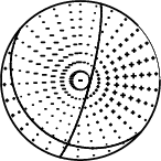
The best solution is
WVFGRD96 13.0 15 80 -70 3.68 0.7258
The mechanism corresponding to the best fit is
|
|
Figure 1. Waveform inversion focal mechanism
|
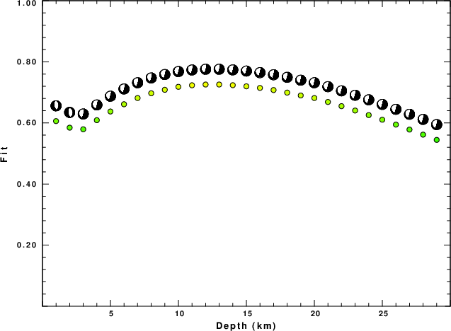
The best fit as a function of depth is given in the following figure:
|
|
Figure 2. Depth sensitivity for waveform mechanism
|
The comparison of the observed and predicted waveforms is given in the next figure. The red traces are the observed and the blue are the predicted.
Each observed-predicted component is plotted to the same scale and peak amplitudes are indicated by the numbers to the left of each trace. A pair of numbers is given in black at the right of each predicted traces. The upper number it the time shift required for maximum correlation between the observed and predicted traces. This time shift is required because the synthetics are not computed at exactly the same distance as the observed, the velocity model used in the predictions may not be perfect and the epicentral parameters may be be off.
A positive time shift indicates that the prediction is too fast and should be delayed to match the observed trace (shift to the right in this figure). A negative value indicates that the prediction is too slow. The lower number gives the percentage of variance reduction to characterize the individual goodness of fit (100% indicates a perfect fit).
The bandpass filter used in the processing and for the display was
cut o DIST/3.3 -40 o DIST/3.3 +50
rtr
taper w 0.1
hp c 0.03 n 3
lp c 0.08 n 3

|
|
Figure 3. Waveform comparison for selected depth. Red: observed; Blue - predicted. The time shift with respect to the model prediction is indicated. The percent of fit is also indicated. The time scale is relative to the first trace sample.
|
|
|
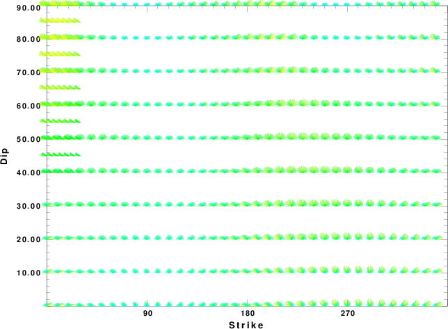
Focal mechanism sensitivity at the preferred depth. The red color indicates a very good fit to the waveforms.
Each solution is plotted as a vector at a given value of strike and dip with the angle of the vector representing the rake angle, measured, with respect to the upward vertical (N) in the figure.
|
A check on the assumed source location is possible by looking at the time shifts between the observed and predicted traces. The time shifts for waveform matching arise for several reasons:
- The origin time and epicentral distance are incorrect
- The velocity model used for the inversion is incorrect
- The velocity model used to define the P-arrival time is not the
same as the velocity model used for the waveform inversion
(assuming that the initial trace alignment is based on the
P arrival time)
Assuming only a mislocation, the time shifts are fit to a functional form:
Time_shift = A + B cos Azimuth + C Sin Azimuth
The time shifts for this inversion lead to the next figure:
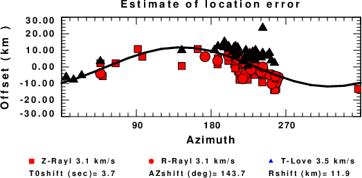
The derived shift in origin time and epicentral coordinates are given at the bottom of the figure.
Velocity Model
The WUS.model used for the waveform synthetic seismograms and for the surface wave eigenfunctions and dispersion is as follows
(The format is in the model96 format of Computer Programs in Seismology).
MODEL.01
Model after     8 iterations
ISOTROPIC
KGS
FLAT EARTH
1-D
CONSTANT VELOCITY
LINE08
LINE09
LINE10
LINE11
      H(KM)   VP(KM/S)   VS(KM/S) RHO(GM/CC)         QP         QS       ETAP       ETAS      FREFP      FREFS
     1.9000     3.4065     2.0089     2.2150  0.302E-02  0.679E-02   0.00       0.00       1.00       1.00
     6.1000     5.5445     3.2953     2.6089  0.349E-02  0.784E-02   0.00       0.00       1.00       1.00
    13.0000     6.2708     3.7396     2.7812  0.212E-02  0.476E-02   0.00       0.00       1.00       1.00
    19.0000     6.4075     3.7680     2.8223  0.111E-02  0.249E-02   0.00       0.00       1.00       1.00
     0.0000     7.9000     4.6200     3.2760  0.164E-10  0.370E-10   0.00       0.00       1.00       1.00
Last Changed Thu Sep 17 11:42:57 CDT 2026